Thunder, sheets of rain, and a city on edge
Delhi spent Saturday flipping between relief and disruption. The India Meteorological Department (IMD) issued a Delhi-NCR red alert on Saturday evening, August 23, 2025, flagging heavy rain, thunderstorms, and lightning for the next three hours and warning of more unstable weather into Sunday. The alert followed a day of intense showers across the national capital and its suburbs, which eased the sticky heat but pushed roads and drains to their limits.
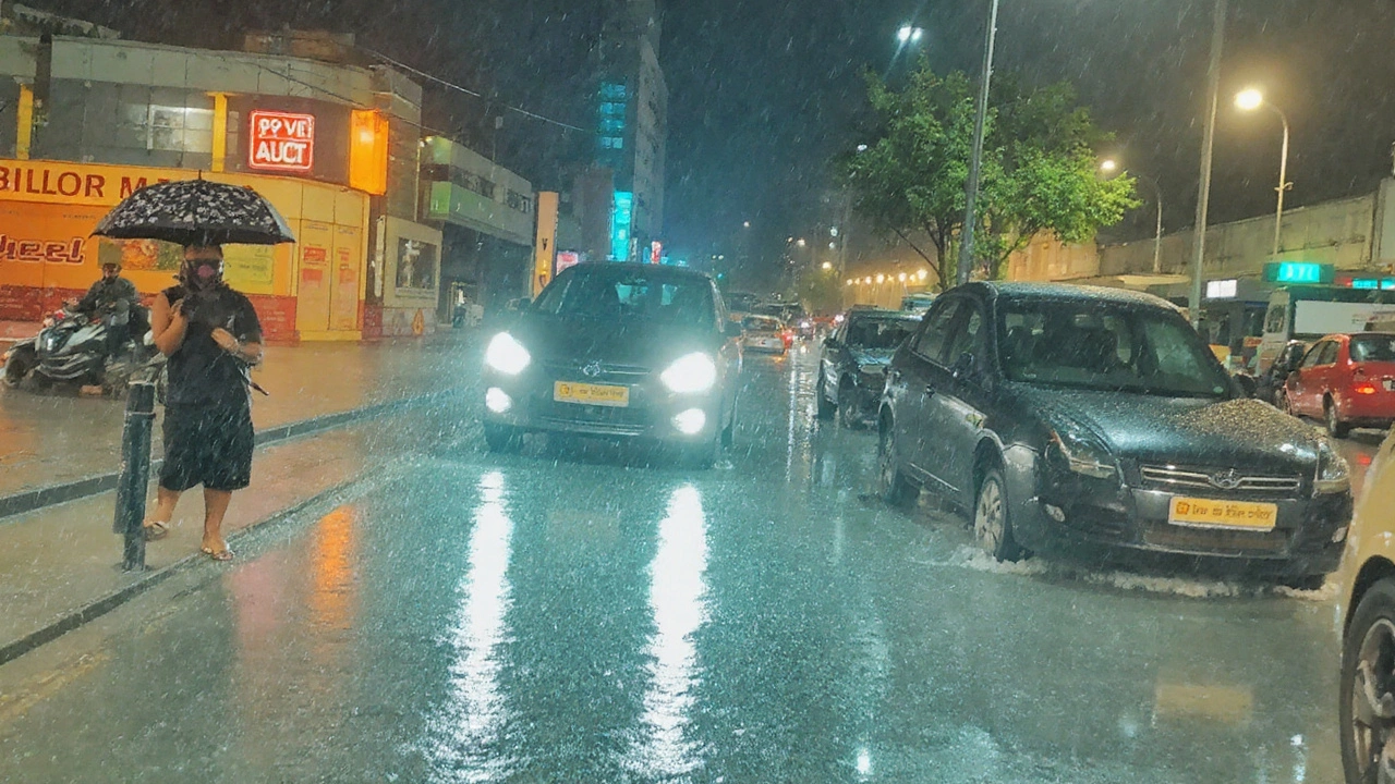
Showers swept through northern, central, southern, and southeastern belts through the afternoon, with bursts strong enough to slow traffic to a crawl and pool water across low-lying stretches. The IMD said moderate to heavy rain could arrive in waves with gusty winds around 30–40 kmph, and that thunder and lightning would remain a risk. Among the localities flagged for rain and gusts were Civil Lines, the Red Fort area, Lajpat Nagar, Narela, Bawana, Alipur, and the ITO complex—places where even short, intense downpours are known to trigger surface flooding.
On the ground, civic teams spent much of the day clearing choke points. The Public Works Department’s flood control room logged at least 10 complaints about waterlogging and said most were handled within an hour. That quick turnaround helped, but it didn’t spare commuters. Vehicles waded through knee-deep patches in some pockets, while others took detours to avoid underpasses and stretches that flood easily after a sharp burst.
Temperatures tracked the weather swing. The maximum settled at 34.5°C, a shade (0.3°C) below the seasonal normal, while the minimum touched 25.7°C, 0.8°C below usual. By early evening, humidity had climbed to 76 percent—high, but typical when steady rain cools the city and leaves moisture hanging in the air.
Rain often scrubs the air, and it did on Saturday. The Central Pollution Control Board recorded an Air Quality Index (AQI) of 93 at 6 pm—firmly in the “satisfactory” band of 51–100. That drop is common when showers knock particulates out of the lower atmosphere. The catch: if storms break into long dry intervals on Sunday, construction dust, traffic emissions, and moisture can mix to push AQI higher again, especially in the evening.
The bigger concern was the Yamuna’s rise. With steady rain feeding tributaries, authorities moved to set up flood relief camps in Mayur Vihar as a precaution. The move is standard when the river shows a sustained upward trend, especially with more rain forecast and potential inflows from upstream. Officials typically track releases from the Hathnikund Barrage in Haryana, which can change river levels in Delhi within hours. For now, the message to families living along the floodplain is simple: keep documents and essentials ready, follow advisories, and move early if asked.
Delhi knows its flood-prone spots—underpasses, dips near flyovers, and stretches where drains silt up or construction blocks outflows. Places like the ITO complex, the Ring Road along the floodplain, and the approaches to old bridges demand extra caution during a squall. While Saturday’s tally of official complaints was modest, that number rarely captures the full picture during a fast, citywide downpour. Many residents push through without calling helplines, and small businesses often pump out water themselves to reopen quickly.
Across the National Capital Region, conditions mirrored the capital through the afternoon: short, intense bursts, milder patches in between, and wind gusts that pushed branches and loose hoardings around. The red alert covers the wider urban belt—Noida, Gurugram, Ghaziabad, and Faridabad included—because the same storm bands can pivot within an hour. Localized flooding is possible even when a neighboring district stays relatively dry.
What makes days like this disruptive is not just the volume of rain, but the rate. Delhi’s dense built-up surface sheds water quickly, and drains clog under sudden load. In many neighborhoods, backyard pumps and small sumps aren’t designed for cloudburst-style bursts. Even with pre-monsoon de-silting, heavy leaf litter, plastic waste, and construction debris can block flow paths when the first wave hits.
The IMD’s color-coded alerts help decode the risk. Red means take action—expect severe weather that can damage property, disrupt power, block roads, and strain emergency services. An orange alert signals “be prepared,” while yellow is “be updated.” Saturday’s red tag is as high as it gets in the warning system, which is why authorities lean toward early staging of pumps, barricades, and relief camps, even if the worst case doesn’t materialize everywhere.
For commuters, the hazards come fast. Standing water hides potholes and open manholes. Underpasses can fill unevenly, trapping low-clearance cars. Two-wheelers lose grip in diesel slicks near bus bays and depots. If you must travel during a burst, stick to main corridors with better drainage, avoid underpasses until police clear them, and don’t tailgate—sudden braking on wet paint or metal grates can send vehicles sliding. If your route crosses areas near the floodplain, build in extra time. And if lightning is frequent, wait out the peak—thunderstorms in the monsoon usually pass in 20–60 minutes.
Inside neighborhoods, simple steps help. Keep ground-floor sockets off where water could seep in. Move vehicles from basements to upper levels early if your complex has a history of flooding. Clear balcony drains and courtyard grates so water doesn’t back up into living spaces. Societies with diesel generators should check exhaust placement; floodwater can push fumes into stairwells if vents sit low.
Shopkeepers and small warehouses can reduce damage with quick checks: lift cartons onto pallets, unplug extension boards from floor-level outlets, and move stock away from gates that swing open under water pressure. For roadside vendors, tarpaulin tie-downs matter—gusty winds will test every loose knot.
Public agencies spent the afternoon in reactive mode—pumping out flooded pockets, clearing fallen branches, and watching underpasses that flood rapidly in a cloudburst. Contingency plans in recent years have added portable pumps and backup power at problem points. Those measures help clear roads faster once the rain tapers off, but they’re not magic. When downpours arrive in back-to-back cells, water can outpace discharge capacity for a while.
If you live close to the Yamuna or its drains, keep an eye on advisories. Even without record water levels, backflow through smaller outfalls can push water into lanes near the floodplain. Evacuation in these zones usually starts with the most vulnerable—informal settlements on the embankments, ground-floor homes, and shops with no easy storage above waist level. Relief camps in Mayur Vihar are geared for short stays, with the aim of moving people early, not in the middle of the night.
Lightning and gusts bring their own risks. Unplug nonessential appliances, especially routers and set-top boxes that surge easily. Avoid sheltering under lone trees. If you’re outdoors when thunder is close, get inside a building or a closed, hard-top vehicle. Metal sheds without proper grounding are not safe during a thunderstorm.
One upside to a rainy day is cooler nights and a break from the week’s stickiness. Saturday’s readings suggest that trend will hold if clouds linger overnight. If they clear, temperatures can swing—muggy before dawn, a bit steamy after sunrise, and then back to breezy if another storm line moves in after noon.

What the forecast says next, and how to get through it
The IMD expects similar weather into Sunday—more rain spells, rumbling thunderstorms, and lightning over several pockets of the city. Gusts around 30–40 kmph are likely to return with stronger cells. That setup means urban flooding can pop up quickly where drains are already carrying a load from Saturday. NCR cities should plan for the same pattern: bursts of heavy rain separated by quieter gaps that can last an hour or two.
Authorities will keep watch on river levels through the night and into Sunday. Continuous rainfall in the catchment can feed the Yamuna with a lag. Flows from upstream, if increased, typically raise levels in Delhi within several hours. That’s why preparedness—staged camps, stocked pumps, and staff on standby—often arrives before the most visible signs of flooding.
For residents, staying ahead of the curve is mostly about timing and choices. If the sky turns slate-gray and winds pick up, pause nonessential travel. If you’re out, pick a route that hugs elevated corridors, and keep a safe buffer from trucks that throw up large rooster tails of water. In cars, keep revs steady in pooled sections to avoid stalling; on bikes, ride slow and upright. If the rain softens, that’s the best window to run errands and return before the next cell.
Here’s a quick checklist that works during a red alert day:
- Charge phones and power banks before the evening peak.
- Secure balconies, planters, and loose objects that can fly in gusts.
- Avoid parking under trees or billboards; wind gusts can bring branches down.
- Keep essential meds, IDs, and a small torch in a zip bag near the door if you live in low-lying areas.
- Do not lift manhole covers to drain water—fast-moving flows can pull someone in.
- Report dangling wires or sparking junctions and keep children away from pooled water near power boxes.
There’s a broader monsoon story behind days like this. North India often sees sharp, localized downpours when moist southwesterlies collide with wind shifts near the surface and a trough sharpening over the plains. The result is a short, heavy burst that overwhelms local drainage, then a lull, then another burst as the next cell rides in. City systems are improving—more pumps, better de-silting—but the mix of concrete, narrow drains, and high vehicle density makes every sharp storm a test.
The city’s recent history offers reminders. In 2023, water levels on the Yamuna crossed long-held marks and large parts of the floodplain saw evacuation. Many fixes followed—cleaner outfalls, repaired embankments, and staging plans for relocation. Those changes mean faster response, but rain that arrives all at once can still cause short-term pain. Saturday’s pattern—short, fierce bursts—is exactly the kind that finds the weak points.
Through Sunday, the essentials won’t change: keep an eye on official warnings, choose travel windows wisely, and don’t take chances around water. The red alert calls for action, not panic. If the rain spreads out and the wind stays under control, much of the city will bounce back quickly between spells. If another heavy band parks over the core, expect slow traffic and fresh pooling until pumps catch up.
For now, the city is in watch-and-respond mode. Crews are out, pumps are running, and relief camps are ready in Mayur Vihar. The weather will decide how hard the next round hits. Plan like it’s coming, and adjust if the sky surprises you with a softer hand.