Heavy rain set to return to Jharkhand after two days
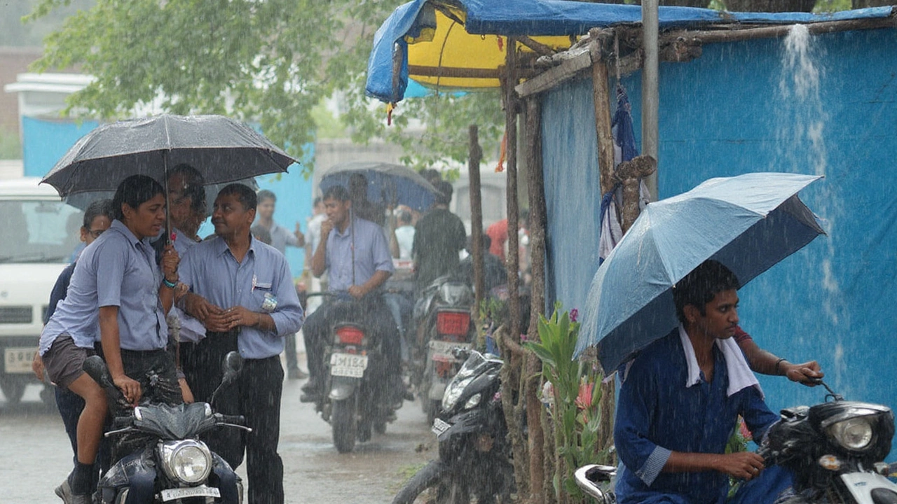
After two hot, sticky days, Jharkhand is staring at a burst of heavy rain. The India Meteorological Department (IMD) has issued an alert for multiple districts, flagging heavy to very heavy showers with a chance of isolated extreme rainfall once the current lull breaks. The trigger is a fresh monsoon pulse consolidating over east and central India, with moisture sweeping in from the Bay of Bengal.
IMD forecasters say the active spell will not be limited to Jharkhand. Odisha and Gangetic West Bengal are in the same weather corridor, and that usually means widespread rain bands shifting northwest across our state. In simple terms: once the monsoon trough strengthens and the low-pressure area nudges inland, Jharkhand tends to get long, soaking spells rather than short, sharp showers.
Here’s the broad timeline people should plan around. For roughly 48 hours, expect warm, humid conditions with cloud build-up and patchy showers at best. After that, the rain ramps up—first as scattered heavy showers, then spreading across districts with a few pockets catching torrents. Thunderstorms and lightning are likely during the onset phase; gusty winds can also show up with squalls.
Temperature-wise, the coming rains should knock back the heat. Daytime readings have been hovering roughly between 23°C and 29°C in many places, and the cloud cover will keep afternoons cooler. Nights could feel muggy between spells, but once the persistent rain sets in, the air should turn noticeably easier to breathe.
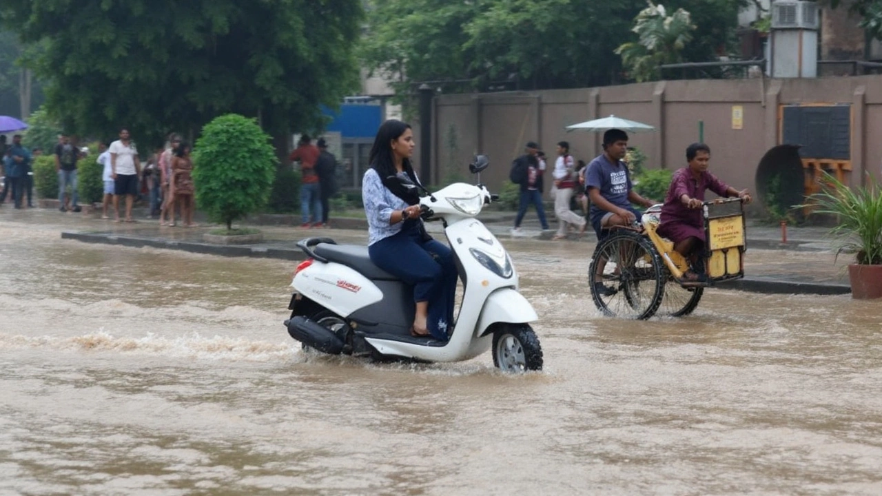
September is among Jharkhand’s wetter months, and eight to fifteen rainy days in the month is common. This round aligns with that pattern. The difference with an “alert” is intensity: heavy rain in a short window can overwhelm drains, push up local stream levels, and slow road traffic even if the weekly totals are normal for the season.
Ranchi, Jamshedpur, Dhanbad, Bokaro, Hazaribagh, and adjoining areas are all in line for widespread showers, according to early model signals. Central and southern belts often see sustained bands when the monsoon trough sits to our south or runs along the Chotanagpur Plateau. If the low-pressure system deepens, eastern districts can catch heavier bursts first, with the belt shifting inland within 12–24 hours.
Flooding isn’t automatic, but a few days of heavy rain can push rivers and reservoirs to watch levels. The Damodar, Subarnarekha, Barakar, and Koel basins are the ones to watch if downpours stack up upstream. Water managers can regulate outflows, but residents near riverbanks and low-lying urban pockets should check local advisories once the rain starts to pound.
The IMD alert is part of a larger countrywide watch this week. Northern and western states have separate storm triggers, while the east and central corridor—where Jharkhand sits—will feel the Bay’s moisture feed. The agency will keep refreshing district forecasts and nowcasts as the system evolves. That means the fine print—timing and exact hotspots—can shift by a few hours either way.
If you commute daily, pencil in extra travel time on the wettest days. Urban waterlogging tends to slow traffic near underpasses and market stretches. Tree fall risk rises in squally storms, and minor power cuts are more common when winds and lightning pick up. Keep devices charged and keep an eye on local updates before you head out.
For farmers, the timing is a mixed bag but mostly positive. The moisture recharge is helpful for standing crops and late Kharif operations. The caution: intense rain in a short burst can waterlog fields and knock lodged crops. Plan for drainage where possible and factor in a short pause before field work resumes—heavy soils need time to shed water.
Industries and mines should prepare for slippery haul roads, reduced visibility in downpours, and potential pit water rise where drainage is marginal. Construction sites need to secure scaffolding and cover raw materials. Rail operations can slow if track sections face waterlogging; road transport will feel the first hit with potholes opening up after the initial storm days.
Lightning remains the top weather hazard in the first phase of this spell. Most injuries happen outdoors and in transit. If thunder roars, get indoors; if you can’t, shelter in a hard-topped vehicle, avoid lone trees and open fields, and keep metal objects away from skin. Phone networks handle storms better than they used to, but saving emergency numbers offline is still smart.
Parents should watch for school advisories. Heavy morning showers often trigger late starts or transport changes even if classes aren’t suspended. If you’re traveling by air from Ranchi, check flight status early on stormy mornings; quick-moving cells can cause short delays during takeoff and landing windows.
On health, there’s the usual monsoon checklist: don’t wade through floodwater unless you must, keep drinking water covered, and check food storage—short power cuts can spoil perishables fast. Standing water around homes can invite mosquitoes; clear small containers and trays after every spell.
Once the heavy phase settles, rain often moderates into long, steady drizzles. That’s the safer part of the cycle for movement and field work. The flip side is road wear and tear becomes obvious by then. Plan for a second round of repairs and detours if the system lingers through the week.
All said, this alert is not unusual for September, but it’s the kind that demands attention for two to three days. Think of it as a concentrated slice of the monsoon: fast, wet, and noisy, then calmer.
What to expect, district-by-district tendencies and how to prepare
While the IMD has warned “multiple districts” without naming each one in advance bulletins, past patterns in similar systems offer clues. Eastern and southeastern belts (for example, East Singhbhum and parts of West Singhbhum) can catch the first heavy arcs when the low moves inland from the Bay. Central stretches—Ranchi, Khunti, and surrounding blocks—often see the rain fill in next. Northern industrial belts—Dhanbad, Bokaro, Giridih—tend to feel the impact as the rain band migrates or when a trailing trough locks in overnight.
Hill and plateau topography breaks rain bands into messy, stop-start bursts. That’s why one neighborhood can see an hour-long deluge while a nearby block reports light rain. Don’t rely only on what you see outside your window; keep an eye on official alerts and neighborhood groups for quick updates on waterlogging and traffic diversions.
Here’s a quick, practical prep list for the next week:
- Charge essentials early each evening: phone, power bank, small lights. Keep a basic first-aid kit and necessary medicines handy.
- Secure balconies and rooftops: tie down loose items, clear drains, and check for seepage points.
- If you drive, avoid underpasses and visibly waterlogged stretches. Don’t cross fast-flowing water—turn around and take a longer route.
- For homes in low-lying areas, elevate extension cords and protect appliances with surge protection.
- Farmers: make a quick pass on field bunds for drainage, store seeds and fertilizers in waterproof bins, and watch for lodging in paddy after heavy gusts.
- Keep children indoors during thunderstorms. If you’re outdoors, seek proper shelter at the first sound of thunder.
- Track official updates from IMD and your district administration for any advisories on schools, roads, or river levels.
Transport and utilities teams usually step up patrols during such spells. Stormwater pumps are brought online, and tree-trimming squads move to known choke points. Still, the first 12–24 hours of heavy rain often outpace response. If you spot blocked drains or leaning trees near power lines, report them early.
As the system matures, rainfall distribution may shift—heavier overnight spells are common when moisture piles up and winds calm. That’s also when visibility drops fast on highways. Truckers and night buses should plan slower legs and longer breaks at safe bays.
For many, the upside is clear: cooler days, cleaner air, and a recharge for fields and reservoirs. Just keep the short window of risk in mind. Treat forecasts as living documents; they sharpen with every update as the monsoon engine moves.
Bottom line for the week ahead: a hot pause, then a wet push. The IMD’s alert covers the timing and intensity risks; your choices cover the rest. Stay weather-aware, and the heavy spell should be manageable. If you only remember one phrase this week, make it this: Jharkhand weather is about to switch gears—plan accordingly.