By Hendrix
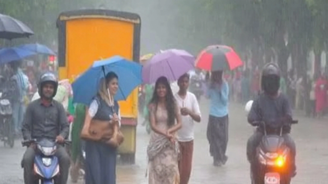
Thirty-two districts in Bihar are on alert after the India Meteorological Department warned of heavy rain across the state, with Gopalganj and Bhagalpur among the areas flagged for intense spells. The advisory lands as monsoon activity ramps up again over the Indo-Gangetic plains, putting focus back on drainage, river levels, and day-to-day disruptions linked to Bihar weather.
IMD’s broader outlook says India is set for above-normal rain in September 2025. For context, September’s long-period average is 167.9 mm, and the agency expects around 109% of that this year. Bihar is part of that story, with the next couple of weeks primed for frequent downpours and a few heavy-to-very-heavy bursts, especially during night and early morning hours.
What the forecast says
IMD’s alert points to a sustained, active monsoon phase over the Indo-Gangetic belt. In practical terms, that means repeated rain episodes rather than a single stormy day. The monsoon trough tends to oscillate near its climatological position in September, and when it dips south or lines up with moisture-laden winds from the Bay of Bengal, Bihar usually gets hit with widespread showers.
While daily intensity will vary, the department expects multiple rounds of moderate rain punctuated by heavier spells across northern and central Bihar, with southern and eastern pockets also in play. Cities and towns with a history of waterlogging should prepare for short-notice disruptions. Low-lying neighborhoods and areas near streams, drains, and small embankments are particularly vulnerable during peak bursts.
Rivers will be the other pressure point. The Kosi, Gandak, Bagmati, Mahananda, Ghaghra, and the Ganga can swell quickly when upstream catchments receive heavy rain. Even if a district sees only moderate showers locally, inflows from Nepal-fed tributaries can push levels up downstream. That’s why river gauges and embankment conditions matter as much as the day’s local forecast.
Nationally, IMD’s September guidance suggests normal to above-normal rainfall in most regions, with some northeastern and extreme southern pockets likely lagging. Bihar sits on the wetter side of that line. The takeaway: keep an eye on district-specific bulletins as timing and intensity can shift within a 24–48 hour window.
Heavy rain brings both sides of the ledger. On the positive side, reservoirs, farm ponds, and aquifers get a lift. Paddy, maize, and sugarcane benefit when fields get steady moisture. On the risk side, prolonged waterlogging can damage newly transplanted paddy, rot roots, and knock down tall crops. In towns and cities, clogged drains and overflowing nalas can trigger rapid surface flooding that recedes slowly if another round of rain follows.
Impact and preparedness
Urban flooding remains the top concern. A few hours of intense rain can overwhelm drains in dense neighborhoods and marketplaces. Expect temporary road closures where underpasses flood, delays on key corridors, and slower bus services. Rail movement can also be affected if track sections see waterlogging. Power cuts may be used as a safety measure where lines or transformers sit in flooded zones.
For rural areas, repeated heavy spells can saturate fields and cut off kuccha roads. Village health centers and schools in low-lying areas may face access issues. If your daily commute crosses a river bridge or busy culvert, plan for extra time and watch local advisories.
Public health risks rise after heavy rain. Stagnant water can drive up mosquito-borne illnesses, while water contamination can lead to diarrheal disease. Keep drinking water safe—boil it where possible—and avoid wading through floodwater to reduce the risk of skin infections and leptospirosis.
Authorities have been asked to stay on alert for waterlogging, sudden flooding, and lightning. District administrations typically activate control rooms, check pumps and portable generators, and clear choke points in drains. Embankment patrols get tighter during active monsoon phases, especially where seepage or erosion was reported in past seasons.
Residents in the alerted districts should keep plans simple and realistic. Quick steps reduce stress when a heavy cell parks over your area.
- Charge phones and power banks; keep a torch handy.
- Move valuables and documents to higher shelves; store essentials in waterproof bags.
- Avoid driving through flooded streets—water depth and road damage are hard to judge.
- Stay off riverbanks and culverts during strong flows; fast water is deceptive.
- Unplug non-essential appliances if water enters your home.
- Follow official bulletins from IMD and your district administration; ignore rumors.
If you live in a locality prone to waterlogging, talk to neighbors and building staff now. Clear debris from drains at the colony level, check sump pumps, and keep sandbags ready for basement entries or low-threshold doors. Small early actions prevent bigger problems later.
Farmers can soften the blow of excess rain with a few timely moves:
- Open field drains and kutcha channels to move standing water out within 24–48 hours.
- Support tall crops (like maize or sugarcane) to reduce lodging in windy bursts.
- Delay nitrogen application on paddy until fields drain; apply after the soil is workable.
- Shift harvested produce and feed to raised platforms; cover with tarpaulins.
- Check fish ponds for overflow points; secure bunds to prevent stock loss.
For schools and offices, watch for short-notice advisories from district authorities during heavy spells. Some local closures or staggered timings may be used if waterlogging persists. Employers should enable remote work where possible during peak rainfall windows.
Travelers should keep plans flexible. If you’re booking intercity buses or trains, monitor schedules up to departure time and opt for refundable tickets when possible. For two-wheeler riders, visibility and slick road surfaces are the main hazards—rain gear helps, but slowing down helps more.
What to track in the coming days:
- IMD district forecasts and nowcasts, which flag short, intense bursts a few hours ahead.
- River gauge updates from the Water Resources Department, especially along the Kosi, Gandak, Bagmati, Mahananda, Ghaghra, and the Ganga.
- Local alerts on embankment stretches that saw stress in previous seasons.
- Drainage status in known choke points—market hubs, bus stands, hospital campuses, and low-lying colonies.
Heavy rain episodes in September are not unusual for Bihar, but back-to-back spells test drainage and patience. With the state inside a wetter phase this month, the smartest move is to stay informed, keep basic supplies ready, and let crews do the ground work—clearing drains, moving pumps, and managing traffic diversions—when the skies open up.
For now, expect more rain than sun across much of Bihar, with the heaviest pockets rotating between districts as the monsoon trough breathes. Gopalganj and Bhagalpur are in the spotlight today, but the focus can shift quickly. Keep an eye on the next advisory, and plan your day around the rain window if your area is on alert.